 Apps and Maps – Using Your Cellphone on a Ride, as published in the March issue of Northwest Horse Source

Today anyone with a smartphone can track their route, geotag photos, plot their speed and elevation, and even share that information on the web. When I was first introduced to navigating, the tools were essentially the same as what Columbus used back when he sailed the ocean blue in 1492. Paper maps and magnetic compasses have been, and in my mind remain, the state of the art for hundreds of years. A few decades ago personal, portable GPS devices hit the world by storm. These wonder gadgets allowed anyone to know their exact position on the planet, in a country, even down to a pinpoint spot on a trail. Now we have new product available that has spun the GPS market on its head: smartphones.
 GPS equipped smartphones use both triangulation measurements from cell towers as well as the constellation of GPS satellites to determine your position. That means cellphone coverage is not required to use these apps. Even though phone GPS devices are not quite as precise as the instruments that professional cartographers use, they are still quite accurate. And like a traditional GPS unit smartphones can also download topographic maps from various sources through any of a multitude of apps. Not too shabby for a tool that you already have in your pocket.
But which app to use? There are hundreds of apps available to map your route and the list seems to grow every day. To answer this question I downloaded ten of the most popular mapping and tracking apps to see which would work best for my purposes. ViewRanger, MotionX-GPS, GPS Hiker, Gaia GPS, EasyTrails, AllTrails, MapMyHike, NeoTrek, TraceMyTrail, and Trimble Navigator.
The Criteria. A mapping app needs to be easy to use and intuitive, otherwise, it will detract from your ride as you fiddle with the various features. In my opinion the best app is one that I 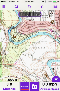 can turn on at the start of a ride, off at the end, and then download my data once I’m home. Knowing my location, the distance I’ve traveled, and my pace as I ride along. While geotagging photos and looking at my speed, distance traveled, and elevation change is fun, the challenge becomes one of avoiding the distraction from the reason we ride; to enjoy the natural world and escape from our daily onslaught of information.
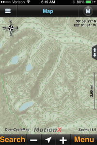
The apps I liked best were MotionX GPS, Gaia GPS, and ViewRanger. They’re built for people who are offline, off the beaten track, and dirty. Each off these apps allows you to easily record, save, and share your tracks.
• The MotionX –GPS app is under a buck in Apples App store and has become my go to tool for recording where and how far I’ve ridden. The Track Recorder is intuitive to use and the track data is easy to share via email.
• Gaia GPS – At $20 Gaia is the most expensive app I’ve ever bought. I don’t regret the purchase. Gaia does everything that MotionX does but adds the ability to download a multitude of high quality topo maps as well. With this addition your smartphone becomes a full-fledged back country GPS.
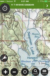 • ViewRanger – The most “”GPS like” app I’ve found. With versions ranging in price from free to $20 ViewRanger can transform anyone’s smartphone into a GPS. If you’ve used GPS units in the past you’ll quickly recognize the similarity with ViewRanger.
 With any phone based GPS app not just the ones I’ve mentioned battery life, and the durability of the phone can be an issue. Using the GPS chipset within your phone is a battery intensive operation in the best of situations.
But what to do with all the data that you collected on your ride? RidersRoutes is a new feature on www.TrailMeister.com that allows riders like you to download popular tracks that other riders have taken onto your phone as well as upload your own tracks to share with others. Simply record your track using a traditional GPS or an app on your GPS enabled smartphone. Once you’ve finished your ride upload the track to TrailMeister to view and share.
As always for more information on this topic and many more as well as the largest directory of horse trails, horse camps, and equine events in North America visit www.TrailMeister.com.