The Global Positioning System, better known simply as GPS, or Global Navigation Satellite System (GNSS), is a tool that is used to measure distance and to help pinpoint locations any place in the world. In fact, it can do so much more than just tell you where you are. And is being used in everything from heart rate monitors to automobiles. If you haven’t heard of GPS, you should get caught up.
The GPS system was first developed and used by the US Department of Defense and allowed for extremely accurate, all weather navigation for the military. Today, it is used throughout the world in a myriad of devices from heart monitors, to car trackers, to phones and emergency locator beacons.
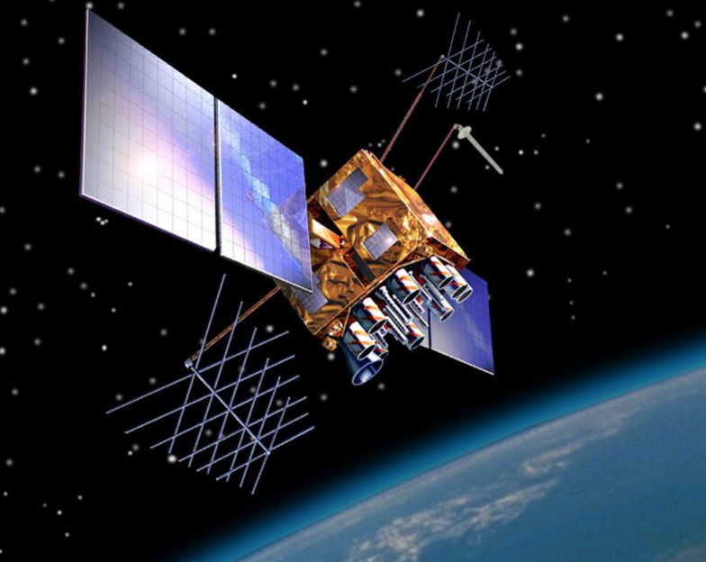
 How GPS Works. Circling the globe is a constellation of many manmade satellites. They orbit the Earth at different locations about 12,000 miles above the surface of the Earth. They are always transmitting information through digital radio signals.
Each of these satellites sends signals to earthbound transmitters at the speed of light. By knowing the length of time that it takes for the signal to get to the receiver, the receivers can make precise measurements. The longer it takes the receiver to receive the signal from the GPS satellite, the farther away the GPS satellite is at that moment. This helps the receiver and the transmitter to deliver precise location information.
The Basic Functions – These three functions are common to virtually any GPS receiver suitable for trail riding.
- Location Finding – A GPS unit accurately triangulates your position by receiving data transmissions from multiple orbiting satellites. Your location is given in coordinates: either latitude and longitude or Universal Transverse Mercator (UTM).
- Navigation – If you have the coordinates for the campsite you’re headed for (taken from a map, resource book, website, mapping software program or other source), a GPS can give you a straight-line, point-to-point bearing and distance to your destination. Since trails rarely follow a straight line, the GPS’ bearing will change as you go. The indicated distance to travel will also decrease as you approach your goal. By combining multiple waypoints on a trail, you can move point-to-point with intermediate bearing and distance guides.
- Tracks – One of the most useful functions of a GPS unit is its ability to lay a virtual “breadcrumb trail” of the route you’ve taken, called a track. You can configure a GPS to automatically drop “points” over intervals of either time or distance. To retrace your steps, simply follow the GPS bearings back through the sequence of track points.
 Key Concepts to Remember
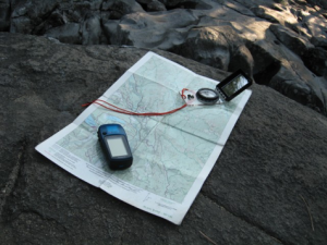
- A GPS receiver does NOT replace a map and compass or the knowledge of how to use them. Your GPS WILL supplement and enhance your navigational abilities with technology. You should always carry a detailed map of the area and a compass.
- A GPS unit is only as good as the map you use with it. Some of the most-useful topographical maps available in the U.S. are the 1:24,000-scale maps published by the U.S. Geological Survey.
- Practice! Before using your GPS receiver as a navigational tool in unfamiliar territory, set yourself up for a successful, enjoyable trip by practicing at home in a familiar area. Familiarize yourself with all of the unit’s features and controls until you’re comfortable with how everything works.
- Read the Manual!
Basic GPS Skills to Learn
Acquiring Satellites
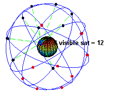
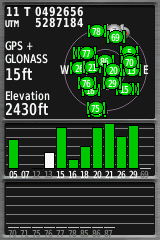 To provide reliable navigational information a GPS receiver needs to receive good signals from at least 4 satellites. To see how many satellites your GPS has “acquired”, go to the Satellite screen: This will display the current configuration of the satellites and the strength of the signals being received.
- More satellites are better. If you see only a few satellites and weak signals, your GPS may not be able to provide reliable information.
- A clear view of the sky is best for an optimal satellite lock. Tree canopy, canyons and tall buildings that obscure the view overhead or of the horizon can impede reception.
Reading Coordinates
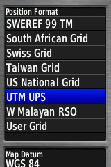 To simplify map navigation, coordinate systems are used. Coordinates divide the map into a grid and identify a particular location by listing its relative position in terms of north/south and east/west. To choose a coordinate system, find the preferences screen. The most common coordinate systems used in GPS navigation are:
- DMS (Degrees/Minutes/Seconds): This is the standard way of listing latitude and longitude: Example: 47°29’44 “, -112°53’02”. In this example, N47° 29′ 44″ indicates that the north/south position is 47 degrees, 29 minutes and 44 seconds north of the equator; while -112° 53′ 02″ places the east/west position at 112 degrees, 53 minutes and 2 seconds west of the Prime Meridian.
- DDM (Degree Decimal Minutes): A decimal version of DMS, For DDM the difference is that the seconds part of the location is converted to a decimal by dividing the seconds by 60. Example: 47.495687, -112.884034. The position remains unchanged.
- UTM (Universal Transverse Mercator): This military-derived grid system is not tied to latitude and longitude. It divides the map into a square grid with the grid lines all 1,000 meters apart. Most topo maps have UTM grid lines printed on them. The system is metric-based and requires no conversion of minutes and seconds. Example: 12T 358097mE 5261970mN. Here, “12T” identifies the map zone, “358097” is the east/west or “easting” number, while “5261970” is the north/south or “northing” number.
Your GPS receiver can automatically display whichever coordinate system you select. Many GPS units can also convert coordinates from one system to another. This is helpful if you’re given coordinates for a location in one system (e.g., UTM), but want to actually navigate in another (e.g., DDM).
GPS Navigation Skills to Learn
Entering Waypoints
 Plotting a route with waypoints is easy. Simply press the MARK button (Consult your users manual for your particular device.). If you’re marking a waypoint where you stand, you can often do this with the single press of a button. You can also add multiple levels of detail: a name (e.g.,”trailhead” or “camp”), the coordinates, the elevation and even a short note. This is very helpful if you’re marking waypoints for the trail ahead, perhaps before you leave home.
- Tip: Before starting a ride, add a waypoint where you’ve parked your truck and trailer.
Following Waypoints:
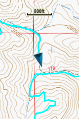
With waypoints in place, your GPS receiver can guide you from one point to another. Use the FIND or GOTO button to identify a particular waypoint target. Then switch to the compass screen where the GPS receiver will give you a bearing and estimate the distance and time of travel.
 Recording Tracks:
When you enable the track recording feature, the GPS unit will automatically set track points as you go, essentially laying a breadcrumb trail to show where you’ve been. With this most useful of tools your GPS allows you to record time, distance, and path traveled.
You can adjust points to be laid at specified intervals of time or distance. The shorter the distance between track points, the more accurate the path back. The intervals you select should depend on the presence of a marked trail, the terrain, the weather and other conditions that you find.
Reception Tips
Establishing a good, clear signal is one of the more common complaints from people who have just purchased a GPS receiver. If you experience this, refer to your owner’s manual or consider the following:
- Satellite lock: Do this in an open area before you head into the trees where reception is more problematic and variable.
- GPS placement: Fix your receiver to a strap on top of your saddle bags or in your shirt, or coat pocket to give it as clear a view of the sky as possible. If separated from your mount, having the GPS on your person is best.
- Avoid obstacles: A GPS receiver’s accuracy (and usefulness) is completely dependent on being able to receive clear transmission signals from four or more satellites. If the “view” to the horizon or overhead is obstructed, that reception can be effectively blocked or diminished, making the GPS unit unreliable. If this occurs, you may need to get to higher, open ground. In the meantime, turn off your GPS to conserve battery power
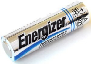 Batteries: Make sure they’re fresh at the start of your trip. And carry spares.
Types of GPS Receivers
There are many types of satellite receivers, from simple data loggers to smartphones with embedded GPSchip(s).
GPS Loggers
These are typically small devices which are used to record track logs. Loggers usually do not provide map displays or navigation features.
In-car Sat Nav
With large color map displays, the main function of in-car Sat Nav devices is to navigate users through city streets. Although some can also record tracks, this is not true of all. Away from a power supply the battery life tends to be quite short (often 3 hours or less).
 Hand-held / Sports Receiver
Hand-held satellite receivers are targeted to the outdoor activities crowd, including horse riders. They provide a small color screen showing a map, and provide navigation features. Generally, these are rugged devices that are at least splash-proof and sometimes even waterproof.
Smartphone / Tablet
Many smartphones and tablets include a GPS chip(s). Apps can be installed to provide the ability to record tracks and provide navigation features.
- Battery life is shortened when the app is switched on.
Stand Alone Versus Dedicated GPS Unit
 The question is, does anyone need a standalone GPS anymore? If you own a smartphone, there’s a strong case to be made for “no.” There are countless apps that’ll turn your Android or iPhone into a GPS. After all your phone is almost always with you, so it doesn’t matter if you’re riding on your horse or in your car, you’ve got GPS.
On the other hand, there are downsides to using your phone as your sole navigation system. For one there’s the matter of power: GPS apps put considerable strain on your smartphone’s battery, so if you’re riding for more than an hour or two, make sure you have a charger handy. It’s a minor hassle, but a hassle all the same.