

Navigating the Trails – Or how to get back to camp in time for dinner!
As seen in the March 2105 issue of West Coast Horsemen
On most trail rides, compass navigation is seldom required. Simply following the trail carefully and checking your map from time to time should get you from campsite to campsite safely. But if you become disoriented, or are just feeling adventurous, a compass becomes a fabulously useful tool.
For many riders land navigation is a foreign topic forcing them to rely on their mount’s sense of direction to get back to the camp because dark. This form of “navigation” has some obvious problems notably what happens if you and your horse become separated? Fortunately there’s a better solution and that is learning a few easy to use navigation techniques before you head out on your next trail adventure. By studying and practicing a few key map, compass, and GPS skills you’ll be sure to enjoy a hot dinner around the campfire, not cold leftovers.
The four main points to remember when
 Declination
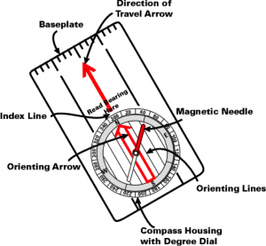
At its heart a compass is just a magnet on a spinning needle. The magnet causes the needle to point toward magnetic north, which is different from the geographic north that your map is oriented to. The measure of difference between these two points is called declination and depending upon where you are located can be substantial. Failing to compensate for declination can easily cause you to be very late for dinner.
Orient a Map
Orienting a map simply means that your map and the surrounding terrain are in alignment. That is to say that north and south on the map correspond to north and south on the ground. This is easily accomplished in four steps.
- Lay your map out on a relatively flat, smooth surface.
- Turn your compass bezel so that due North is at the index pointer.
- Place your compass on your map with the edge of the baseplate parallel to the north-south meridians on the map. The orienteering lines and direction-of-travel arrow should all be parallel with the map lines.
- Turn the map and compass together until the compass needle is “boxed” in the orienting arrow (Red in the Shed).
 Once your map is oriented to the real world. If you know where you are on the map, you should be able to look in any direction and see the objects represented on the map in the same direction.
Take a Bearing
Taking a bearing is just a fancy way of saying that you’re going to figure out which direction you need to go to head back to camp. To make it happen just follow these easy steps.
- Find your current position and your destination on the map that you’ve already oriented.
- Place the flat edge of your compass along a straight line connected the two locations. The direction of travel arrow should be pointing towards your destination.
- Turn the compass bezel so that the red end of the needle is within the orienting box or “red is in the shed”.
- The number displayed at the index line is your bearing; the direction you need to travel.
 Find Yourself on the Map
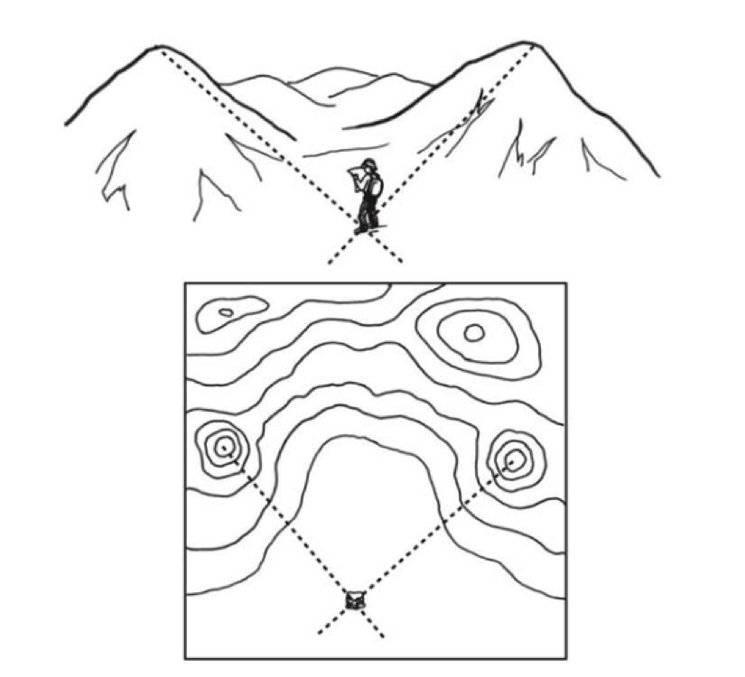
Not sure where you’re at on your map? No problem! With your map and a compass you can use triangulation to find yourself on the map. Despite the formidable sounding name triangulation is simply transferring the bearings of two or more real-world objects to your map to identify your location.
- Point your compass’ direction of travel arrow at a prominent landmark that you can see both on your map and in the real world. Read the bearing.
- Locate the object on the map and place the edge of the compass on that object.
- With the edge on the object, and without touching the bezel, turn the entire compass until the orienting lines within the bezel line up with the orienting lines on the map.
- The edge of the compass forms a line on the map, and you now know you are somewhere along that line.
- Repeat the above steps with another object.
- Where the lines cross marks your location.
If you use a GPS the device does most of the work of triangulation (with satellites instead of landmarks). One very important consideration when using a GPS with a map is to make sure that the GPS is using the same map datum information that is shown on your map.